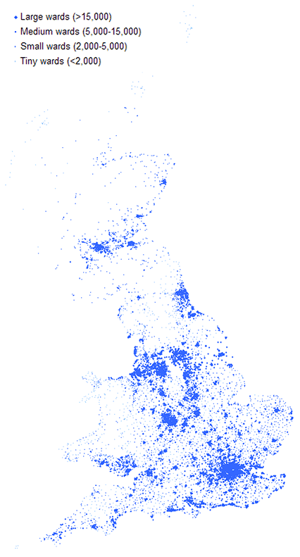
A few years ago I looked after analysis and tools within the Site Research (location analysis) department in Tesco. One of the things that I loved about that job was access to all the cool mapping tools and data. It gave me a much better insight into human geography.
Anyway, below is a chart I produced at one point which I think is rather nice, based on the 2001 census. It shows the distribution of the population of the UK where each point is the population-weighted centroid of a ward. Britain is split up into 408 Local Authorities (average size 140,000, the largest being Birmingham with 977k, with the smallest generally being no smaller than about 25,000 apart from islands like the Scillies), and each of those split into 10,000 Wards which are the units used for election of local government officials (average size 6,000, varying from 100 to 35,000).
(Click on the image to open a larger version in a new window)
I actually produced this particular display in humble Excel. So adding the outline of the country can’t easily be done, though you can see the shape of Britain quite easily really because humans like to live by the sea.
Some things I think are interesting to see on this view:
- It’s amazing to see quite how ’empty’ Scotland is apart from the ribbon of population between Glasgow and Edinburgh.
- The gap of the Pennines between Manchester and Yorkshire is clear to see.
- The North-East (Newcastle, etc.) is quite separated, which probably explains why they have such a strong regional identity.
- London and its surrounding towns is the dominant feature of the whole of the southern half of England.
- Wales is very sparsely (but evenly) populated apart from Swansea and Cardiff in the South.
- This isn’t quite as clear on this chart, but the population in the South is mostly in lots of towns and villages (lots of small/medium wards), whereas the population in the North (Yorkshire/Lancashire/Derbyshire/Humberside) is much more densely packed in large urban wards. This is mainly a reflection of history – the rapid urban development due to the industrial revolution. Although I think geography (those dramatic landscapes) probably matters too.
- There’s a surprising amount of population run along the South Coast.

Did you see this Facebook “map”? I thought it was amazing that just by plotting “friendship” connections you could get such an accurate map of the world and a beautiful image into the bargain. Some interesting things show up too.
http://www.facebook.com/note.php?note_id=469716398919
LikeLike
Love it! Funny how little one sees of China on there. Is there some native Facebook knock-off that dominates in China instead?
LikeLike
Ha! No, better reason than that. Facebook (and Twitter etc.) is blocked in China. Sneaky people with VPNs can tunnel under the Great Firewall though.
LikeLike